History
An Overview of the History of the Town of Chemung, New York
Prehistoric era
The landscape of New York State was formed by glaciers during the late Paleozoic Era, in what was called the Pleistocene Epoch, lasting from 1.8 million to 11,000 years ago, known as the ice age. Carved out by these glaciers, previously known as the Tioga, the Chemung is an old river that winds through the Southern Tier of New York and North East Pennsylvania before feeding into the Susquehanna River below Athens, PA. It eventually empties into the estuary, Chesapeake Bay which empties into the Atlantic Ocean. The history is rich along the old Chemung. The Chemung River Valley is nestled in the Blue Ridge Hills of the Appalachian Plateau.
Native American History
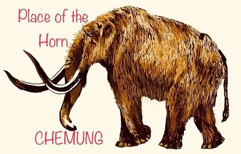
It is said an Algonquin Tribe discovered a mammoth tusk in the banks of the Chemung River. The word Chemung originated from their dialect, Shumounk, meaning “Place of the Horn.â€
The lower Chemung River Valley has long been home to Native Americans with various tribes and cultures. Long houses and villages excavated, date to 800 A.D. in the neighboring Town of Ashland. In the 1700’s the Iroquois’s Six Nations became prominent in the region. Mainly the Seneca Tribe and perhaps the Cayuga too, along with the Delaware people. The area became known as the Iroquois Confederacy. They established a village in the vicinity of the current town with a large acreage of crops and orchards. By the late 1700’s, they no longer used long houses but were living in log homes. An account from an officer with the Sullivan-Clinton Campaign in 1779, “some of the houses were rather large, situated in a well laid out village with a chapelâ€. Chemung became known as the “Western Door and Forbidden Pathâ€, to Genesee and Niagara. European settlers dared not enter the forbidden path.
European Settlement
The first Dutch settlement was established in New York State in 1624 as New Netherland. As late as 1638 the area of land lying to the west of Fort Orange (Albany), was called the "Terra Incognita" or Unknown Land.
Wars before the American Revolution, fought on New York State soil by European Colonists were:
1664, the British army conquered the colony of New Netherland, which was then re-named New York, in honor of the Duke of York and Fort Orange renamed as Albany.
1673 the Dutch once again reclaimed the territory and held it for one year before surrendering it to the English.
1754 - 1763 The French and Indian War. The British and American colonists fought against the French and Canadians, with Native American allies on both sides. By uniting the colonies and building their military strength and confidence, this war set the stage for the American Revolution.
In 1765 New York City hosted the first Colonial Congress, a conference called to discuss the King of England's Stamp Act.
The New York Provincial Congress (1775-1777) was an organization formed by colonists in 1775, during the American Revolution, as a pro-American alternative to the more conservative Province of New York Assembly, and as a replacement for the Committee of One Hundred. It was assembled by Rebels when the Provincial Legislature would not send delegates to the Continental Congress.
1775 - 1783 The Revolutionary War. On May 10, 1775, Ethan Allen, Benedict Arnold and 83 “Green Mountain Boys†surprised the sleeping British garrison at Fort Ticonderoga and took the fort, called ‘The Key to a Continent without firing a shotâ€. This was the first American victory of the Revolutionary War.
New York's inclusion into the Federal Union, 11th of 13 original states.
After serving as a colony of Great Britain for over a century, New York declared its independence on July 9, 1776, becoming one of the original 13 states of the Federal Union.
In 1777 New York's first constitution was adopted on April 20. George Clinton was elected as New York’s first Governor in June. On October 17, the Americans defeated the British at the Battle of Saratoga, one of the decisive battles of the war. This victory marked the turning point of the Revolution, leading to the Americans’ alliance with the French and eventual victory.
On April 2, 1784, Legislature changed the name of Tryon County to Montgomery, in honor of the American General, Richard Montgomery, who gallantly fell at Quebec. Montgomery County embraced all that part of the State, west of a line running nearly north and south through the present County of Schoharie. It was by the same act, Montgomery County was divided into five districts, named Mohawk, Canajoharie, Palatine, German Flats, and Kingsland.
Town of Chemung, Montgomery County established. Along with establishments of local towns and counties.
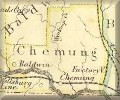
On March 7, 1788, an act passed defining the boundaries of the several counties of the State. The County of Montgomery was declared to contain all that part of the State bounded easterly by the counties of Ulster, Albany, Washington and Clinton; southerly by the State of Pennsylvania; and westerly and northerly by the west and north bounds of the state. Another act passed on March 22, 1788, from which the legislature erected a new town in Montgomery County, the Town of Chemung, lying on the Owego and Tioga Rivers.
“March 29, 1836, Chemung County was organized from Tioga County. It comprised the present territory of the county along with the towns of Catherine, Dix, Montour and Cayuta in Schuyler Countyâ€. On February 7, 1854 the Legislature authorized Horseheads to set up for a township by itself. In the spring of 1854 the northern portion of Chemung County being towns of Catherine, Dix and part of Cayuta was taken away to form Schuyler County with a slice from Steuben and Tompkins.
When Schuyler County was formed, April 17, 1854, a small portion of the township of Cayuta was saved to Chemung County and that along with a portion from Erin township was erected and became the township of Van Etten.
On April 7, 1856, the legislature passed an act creating another new township, Baldwin which was made up from the northern part of Chemung.
The town of Ashland was formed in 1867 from parts of the towns of Chemung, Elmira and Southport.
References: History of Madison County, NY (State of New York), Old Town of Chemung, Montgomery County, by Capt. Charles L. Albertson, History of Chemung County New York 1836-1892 by Ausburn Towner
American Revolution, Battle of Chemung and Battle of Newtown, 1779
Two battles took place in Chemung County in 1779. The Iroquois became allies with the British, who held the support of the Six Nations of the Iroquois and of many colonists who were opposed to the rebellion, known as Loyalists or Tories. Their tactics of raiding settlements and killing the colonists was causing the Continentals to lose troops who wanted to be home to defend their family and property. The loss of troops became a threat to the Continental Army’s success. The Iroquois were growing crops to replenish the British Army’s supplies. General George Washington made the decision to send General John Sullivan and General James Clinton into Iroquois country with over 5,000 troops with orders to destroy all villages and crops.
The Battle of Chemung took place in the Town of Chemung on August 13, 1779. It was the first battle of the American Revolution where Continental troops fought against the Native Americans and battle was deemed successful. It is not known how many Native American’s were killed or wounded. Six Continentals were killed and 12 wounded when they were ambushed by the Iroquois, Delaware and British.
The Battle of Newtown took place in the Town of Ashland on August 29, 1779. Casualties were reported as: Continentals: 11 killed 32 wounded. British, Iroquois & Delaware: 17 killed, 16 wounded, 2 captured. The Battle was deemed successful by the Continentals.
In 1791 the final treaty with the Six Nations was signed in Newtown.
Settlement and history of the Town
It is said the earliest known settler was one David Bosworth in 1780 and the Isaac Baldwin Sr. family in 1784. This may have been squatter’s rights as the Original Plot Map was drawn up in 1788. Chemung became a town March 22, 1788.
Rich fertile land as far as you could see was available for a price. It is possible some of the land was awarded to patriots who fought in the war however it has yet to be proven that any land grants were given to men who fought in the Battles of Chemung or Newtown.
Many acres of land were previously developed by the Iroquois and left to be claimed by the newcomers. Virgin white pine filled the mountains along with other varieties of trees. The white pine were massive trees. The town, with a narrow river valley and mountains flanking on both sides, was filled with feeders and creeks and important for the development of the town. Grist Mills and Saw Mills started cropping up on the creeks. At first people starting pouring into the area looking to settle homesteads. Land was becoming crowded in the New England States. Many of the earliest settlers moved in from Pennsylvania, Connecticut, New Jersey and the Counties, Duchess, Orange and Ulster, to name a few, in New York. The only roads were small paths created by the Native Americans who lived there previously. Not all the Native Americans left the area, some stayed behind and the pioneer settlers coexisted with them. Most travel was done on the river. Rafts, Durham boats, canoes were used to navigate the waterways. There are accounts of families arriving with their belongings on oxen carts but their travel was difficult and slow. Ferries were created in order for people to cross the river. They built log homes with 2 stories, some built frame timber homes, depending on their building experience and what building types they left out east. Chemung still has fine examples of the earliest houses. Even today, some of Chemung’s residents descend from its earliest settlers.
In 1825, Chemung was the largest manufacturer within the local communities of Linen, producing 7,726 yards and 1,813 yards of fulled woolen cloth manufactured. The 1825 census for the Town of Chemung showed 1,150 inhabitants and 2,231 in 1835. 5,489 acres had been improved and 42,511 acres remained unimproved.
By the early to mid-1800’s lumber became one of the top commodities. One by one all the white pine was felled and is today, extinct. The mountains and hills were stripped of trees for profit. Logs were rafted down the river for sale or sent to saw mills. Bark was used in tanneries. Many men, some with families moved into Chemung for the profit they could make on the dangerous profession of logging.
The Erie Railroad opened in 1850 and from 1858-1871 the Junction Canal was open and connected the North Branch Canal and the Chemung Canal. There was plenty of work to be found in building and maintaining the canals and railroad, for 10 cents an hour, 10-hour days. Lumber was used to steam the locomotives on the Erie Railroad. The canal provided a means of transporting lumber to other areas and opened up a trade route for many commodities. Once coal was transported through Chemung from Pittston to the Great Lakes by canal, the steam locomotives began using coal.
Many people who lived in Chemung didn’t stay long but moved on to their next employment opportunity. They went where they could make money. These were hard working laborers. As new states opened up, with new land and employment opportunities, these people kept moving west.
Those who stayed, built large comfortable homes and barns and provided well for their family and community. Bridges were built. Mass transportation was available to those who had the need for it. Still, people were always looking for the next opportunity. Between the mid 1800’s and early 1900’s tobacco became the next growing commodity of the times. Tobacco fields became the sight of prosperity. Tobacco barns began popping up in the landscape. They were large barns designed to efficiently dry the large tobacco leaves.
Progress has continued throughout the years and today the Town of Chemung continues to thrive with a balance of agriculture and industry. Interstate 86 and the Norfolk Southern Railroad run along the Chemung River and through the town. Today the river is used for recreational purposes. Also located in Chemung is Maple Hill, a 604 acre State Forest with a limited amount of development, focusing on rustic experiences.
References: A History of the Valley and County of Chemung, Ausburn Towner, New York History Net, Webmaster Stony Brook Search Engine, Stony Brook State Univ. of NY. New York State History, Univ. of Albany. Old Fort Niagara Association, Youngstown, NY in Cooperation with the NYS Office of Parks, Recreation and Historic Preservation, CCNN Web Design.
Contact: Mary Ellen P. Kunst, Town of Chemung Historian
Email: mepk@frontiernet.net Inquiries are reviewed in order of receipt.
More in-depth information can be found at this website: http://www.HistoricalEchoes.weebly.com A Virtual Research Page at this website may prove helpful to you.
Several fires led to the destruction of many town records. Prior to 1836, you might need to check Tioga County for deeds and surrogate records. Chemung County was organized in 1836. Prior to that time, it was part of Tioga County in Owego, NY. Chemung County does have copies of some of Tioga’s records but not all of them.
Please note: Should you require copies of publications or records mailed to you, there could be a nominal fee for postage and media storage, being either CD or Flash Drive. Thank you.
Other useful sites include: Tri-Counties Genealogy and History by Joyce M. Tice, Chemung County Historical Society. Tioga County Historical Society
Contacts:
Tri-Counties Genealogy and History by Joyce M. Tice
Chemung County Historical Society
Chemung Valley Living History Center
Historical Echoes